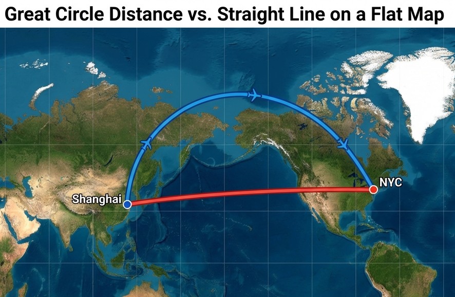
Have you ever looked at a flight map in an inflight magazine and wondered why the line from New York to London curves upward towards the Arctic, instead of going in a straight line? ✈️
It’s not because pilots like the view of Greenland (although it is beautiful). It’s because on a sphere, a straight line on a flat map is not the shortest distance between two points.
Welcome to the mind-bending world of Great Circle Distance.
🗺️ The Mercator Deception
Most of the maps we see online (including Google Maps, until recently) use the Mercator Projection. This projection is great for navigation because it preserves angles, but it’s terrible for size and distance, especially as you get closer to the poles.
On a flat Mercator map:
- Greenland looks as big as Africa (Africa is actually 14x bigger!).
- Antarctica looks like an infinite ice wall.
- Straight lines look like the shortest path, but they are actually longer “Rhumb lines”.
🌐 What is a Great Circle?
To find the true shortest path between two points on Earth, you have to cut through the sphere. Imagine slicing an orange 🍊 perfectly in half so the slice passes through two specific cities and the center of the orange. The rim of that slice is the Great Circle.
If you were to stretch a string tight between two points on a globe, it would naturally follow the Great Circle path. On a flat map, this path looks like an arc.
🧮 The Haversine Formula
So how do we calculate this mathematically? This is where CityDistance.io comes in. We use the Haversine formula, a piece of trigonometry that scares high school students but is essential for sailors and pilots.
In simple terms, it takes the latitude and longitude of two points and calculates the distance along the surface of a sphere.
// Simplified Haversine Formula
const R = 6371; // Earth's radius in km
const dLat = (lat2 - lat1) * Math.PI / 180;
const dLon = (lon2 - lon1) * Math.PI / 180;
const a =
  Math.sin(dLat/2) * Math.sin(dLat/2) +
  Math.cos(lat1 * Math.PI / 180) * Math.cos(lat2 * Math.PI / 180) *
  Math.sin(dLon/2) * Math.sin(dLon/2);
const c = 2 * Math.atan2(Math.sqrt(a), Math.sqrt(1-a));
const distance = R * c;
This is the math running behind the scenes when you use our triangulation tool.
🎮 Why This Matters for SatZoom Players
If you play geography guessing games like SatZoom, you might have been confused before.
“I guessed Finland, and it says the target is 2,000km away. But on my map it looks much further!”
That’s because SatZoom uses the Great Circle distance. Because standard maps stretch northern countries horizontally, distances in Europe and Canada can be very deceptive visually.
Pro Tip: Don’t trust your eyes on a flat map. Trust the numbers. Or better yet, use a tool that understands spherical geometry—like ours! 😉